

Al-Jabal Agriculture is Teaching Iraq's Desert to Read Its Own Soil
Al-Jabal Agriculture blends satellite imagery, soil labs and AI to help Iraqi farmers cut waste and boost yields, turning inherited guesswork into precision, data-driven farming.
Growing up between the Tigris and Euphrates, the twin veins that pulsed through the heart of Mesopotamia, Mohammed Nabeel Al-Ruwaishdi inherited one of agriculture's oldest origin stories, where irrigation turned river silt into harvests, and harvests helped raise some of humanity's earliest cities.
"That's the water I grew up on," he tells StartupScene, recalling land so rich in organic matter that crops needed little fertiliser to grow. It would take him years to recognise just how particular that abundance was, and what could go wrong when its rules were carried into land the rivers had never reached.
By the time he was 15 years old, he had found his place somewhere along the agricultural chain, trading vegetables from a small shop in Najaf, learning crops through the everyday business of weighing, selling, and watching what survived the journey to market. Agriculture remained somewhere in the background even as his career veered in nearly every other direction, moving between 15 projects; some folding, some funding his next venture. "Every one of my projects, whether they failed or succeeded, taught me something," he insists.
Across one project after another, Al-Ruwaishdi saw a promising idea buckle under the wrong team—or no real team at all. In Iraq, he says, businesses often become dangerously dependent on a single person, turning one resignation into the possible collapse of an entire company. "You can have the money, the timing, the idea and the tools, but without the right people around you, and without knowing how to manage them, none of it works," he says.
The winding route eventually brought him back to the land, only this time he was looking at it from hundreds of kilometres above. At Al-Karkh University of Science, where he studied Remote Sensing and Geographic Information Systems, Al-Ruwaishdi learnt how satellites could detect changes in vegetation, moisture, and soil conditions across farmland too vast for any one person to inspect. Yet the technology rarely left the university. "I noticed that most of these technologies were used in research while their actual application in Iraqi agriculture remained very limited," he explains. Farmers continued making high-stakes decisions through inherited routines and whatever they could observe by walking the land.
"That’s where the idea began," Al-Ruwaishdi says. "Why not turn satellite data into decisions that help farmers increase production and reduce waste?"
The answer first took shape while he was preparing geological maps for an agricultural investor. Al-Ruwaishdi suggested monitoring the investor's farm by satellite, free of charge, around 1,500 dunams, just large enough for problems to develop far beyond what one person could easily inspect. While following crop growth week by week, Al-Ruwaishdi recalls, "We discovered weak areas that couldn’t have been noticed with the naked eye." They went on to inspect the flagged areas on the ground, finding that the land did match what the satellite had detected. "Once we verified the results, I realised this technology was not just pretty pictures, but a tool capable of transforming the entire way agriculture is managed," he smiles.
That 1,500-dunam experiment became the first chapter of Al-Jabal Agriculture, founded in 2023 and built around the mismatch between farmers moving into new terrain while farming according to old assumptions. And as agricultural investors expanded into Iraq's desert, many brought techniques inherited from the fertile river plains, but desert soil follows another set of rules. "The soil type is different. The salinity is different. The soil's water-retention capacity is different," Al-Ruwaishdi explains. "The problem wasn’t a shortage of fertiliser, but a shortage of the data needed to make the right decision."
Al-Ruwaishdi saw two habits driving waste: farmers applying fertiliser at rates dictated by regional convention rather than soil analysis, and farmers repeating methods that had worked on other fields, assuming experience would transfer neatly. Both ignored the specificity of the land, and how, even nearby plots, may hold water differently or carry different salt concentrations. "A farmer sees only a small part of his land," Al-Ruwaishdi says. "A satellite monitors the entire field in a single image."
Al-Jabal has also secured a six-figure investment from Iraqi investors, alongside a partnership with Al Sharqiyah Holding focused on exchanging expertise, aligning visions, and developing a clear growth plan for Al-Jabal. “The investment is mainly being used to scale Al Jabal's operations and technology across Iraq. We're investing in our technical infrastructure, further developing our AI-powered agricultural platform, and expanding our operational capacity and team,” he says.
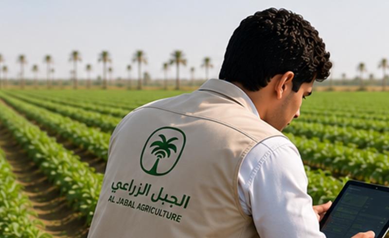
The platform uses data from Sentinel-2, a European satellite mission, extracting 12 indices relating to crop health—vegetation, moisture, surface temperature, nitrogen and salinity among them. But Al-Jabal doesn't treat those signals as a final diagnosis; once an area of concern is flagged, a team visits the farm, collects soil, water or plant samples, and sends them to a lab. Remote-sensing specialists sit with agricultural engineers to compare satellite data against field and lab results before producing a recommendation. "We combine satellites, field inspection, laboratory analysis and the expertise of agricultural engineers," Al-Ruwaishdi goes on. "We don’t just offer images. We offer an agricultural decision built on data."
The final report includes crop condition, detected problems, an irrigation plan, a fertilisation schedule and agricultural priorities—stripped of technical jargon. "Farmers don't need to know what NDVI or LST means," he states. "They need to know what to do." The science gets translated before it ever reaches the field; for farmers who can't read or write, Al-Jabal turns data into coloured maps and plain instructions.
But asking a farmer to trust a coloured image over a lifetime of accumulated instinct was never going to be a simple sell. "At first, it was difficult to convince farmers that a satellite image could help them make farming decisions," Al-Ruwaishdi tells us. "We didn’t try to convince them with words, relying instead on results." And every successful season brought in new farmers.
"The hardest stage was building trust," he confirms. "It took years of fieldwork and proven results before farmers began to see data as an essential part of managing their farms."
The numbers help make the case: Al-Jabal says its approach has reduced agricultural waste by around 25%, while productivity has risen by close to 30% in some fields. The company has grown from the 1,500 dunams it monitored in 2023 to more than 20,000 dunams today across several Iraqi governorates, and its team grew from seven people to 20 within six months.
The next stage is implementation, not just diagnosis. Al-Jabal is working to connect its satellite analysis with agricultural drones, using Variable Rate Application to treat only affected areas with calculated quantities. “The drone applies inputs only where they are needed, reducing costs, minimising waste, and improving productivity through precision agriculture,” he says. AI is also being integrated to speed analysis and sharpen recommendations.
"The platform we're building is an Iraqi platform, tailored to Iraqi conditions," he says. What started as a 1,500 dunam experiment has since grown into more than 30 agricultural projects across Iraq, spanning over 20,000 dunams of farmland, “with clients ranging from individual farmers to agricultural investors running large-scale centre-pivot operations, particularly in the country's desert regions.” Demand elsewhere is emerging, and Al-Ruwaishdi hopes to carry Al-Jabal's experience into other regional markets. Within the next year, he's aiming to grow that footprint fivefold by targeting over 100,000 dunams under management as it pushes into new territory.
Over the next five years, he's as focused on changing behaviour as expanding territory. "We aspire for data-driven agriculture to become the standard in Iraq," he says. "We want every investor and every farmer to be able to make decisions based on data rather than guesswork."
There’s something fitting about that ambition beginning between two rivers that once taught humanity how to farm at scale. Al-Ruwaishdi grew up with the benefits of that inheritance all around him: fertile soil, generous water and land that seemed to answer readily when planted.
Now, through Al-Jabal, he’s confronting the limits of inheritance. What nourished one field may overwhelm another. What generations have always done may not be what a changing landscape needs next.
- Previous Article Rabeh Raises $8.5 Million to Build Saudi Investment Platform
- Next Article ZenHR Raises $6 Million to Expand AI-Powered HR Platform